

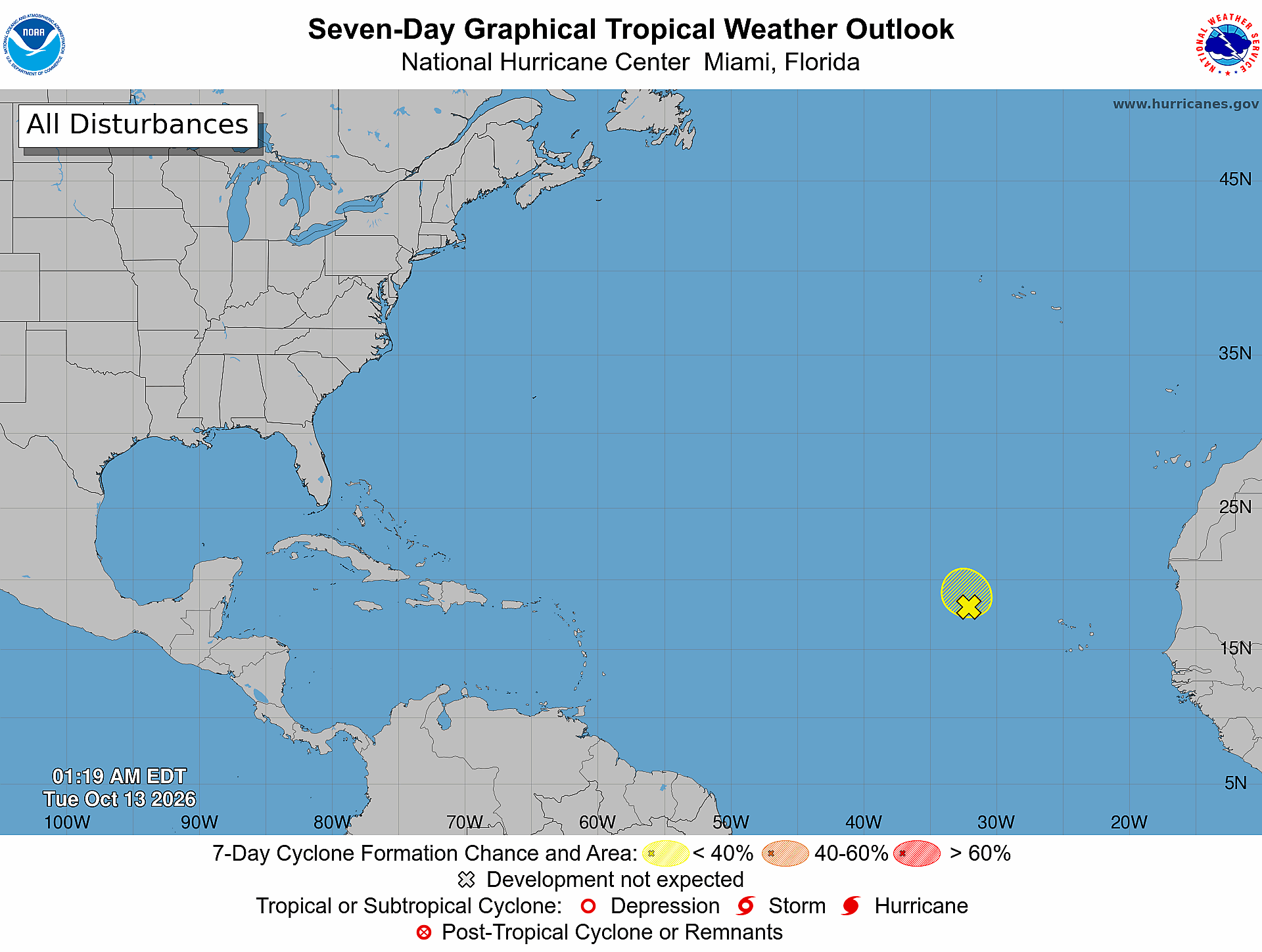
Florida hurricane-season check for October 13, 2026: The National Hurricane Center’s 2:00 AM EDT Atlantic outlook monitors one disturbance in the eastern tropical Atlantic, several hundred miles west of the Cabo Verde Islands. [1] NHC gives it a low 10% formation chance through 48 hours and a low 10% chance through seven days. [1] Conditions can change; reopen the official products for the newest information.
Official Atlantic Outlook at a Glance
- Printed text outlook issue time: 2:00 AM EDT Tuesday, October 13, 2026. [1]
- Product: ABNT20 KNHC 130519 / TWOAT. [1]
- Area covered: The North Atlantic, Caribbean Sea, and Gulf of America. [1]
- Monitored formation area: An elongated low-pressure area several hundred miles west of the Cabo Verde Islands, producing a large area of disorganized showers and thunderstorms well east of its center. [1]
- Formation chance through 48 hours: low, 10 percent. [1]
- Formation chance through seven days: low, 10 percent. [1]
- Forecaster: Reinhart. [1]
Eastern Tropical Atlantic Disturbance
NHC says further development appears unlikely as the low moves slowly northward to north-northwestward and encounters stronger upper-level winds today and tonight. [1] Regardless of development, NHC expects heavy rainfall to continue today across western portions of the Cabo Verde Islands, where some flooding is possible. [1]
What the Seven-Day Graphic Shows
The official seven-day graphic is timestamped 1:19 AM EDT Tuesday, October 13, 2026. It shows one yellow hatched formation area and a yellow disturbance marker in the eastern tropical Atlantic, west of the Cabo Verde Islands; no active named tropical cyclone appears on this graphic. [2] The yellow legend denotes a less-than-40% seven-day formation area. [2] Use the text product—not the color band—for the exact 10% chances. [1]
What This Means for the Treasure Coast
This outlook does not state that the eastern Atlantic disturbance threatens Port Saint Lucie, Jensen Beach, Fort Pierce, or Vero Beach, and it provides no track toward Florida. [1] That is a bounded reading of the current outlook, not a guarantee about later forecasts or ordinary local weather. Practical guidance from The IT Guys: Treasure Coast residents and businesses should keep checking current NHC products and local National Weather Service alerts. [1]
A Practical Hurricane-Season Tech Check
Practical guidance from The IT Guys: Charge power banks, confirm emergency alerts are enabled, keep important contacts available offline, and maintain a separate backup of essential documents and business data. [3] [4] These are practical technology extensions of official prepare-ahead guidance, not verbatim NOAA or NWS checklist items, and they do not guarantee safety or business continuity. The National Weather Service recommends knowing your evacuation zone, assembling an emergency kit, checking emergency equipment, and writing or reviewing a family emergency plan. [3] NOAA advises understanding hurricane risk, preparing before danger arrives, keeping multiple ways to receive forecasts and alerts, and knowing what to do before, during, and after a storm. [4]
Official Sources and Preparedness Links
- [1] NHC Atlantic Tropical Weather Outlook text product
- [2] NHC Seven-Day Graphical Tropical Weather Outlook
- [3] National Weather Service hurricane planning guidance
- [4] NOAA hurricane preparation resources
Reporting cutoff recorded by The IT Guys: 7:05 AM EDT (11:05 UTC) on October 13, 2026. [recorded by The IT Guys] This report reflects the 2:00 AM EDT text outlook and the 1:19 AM EDT graphic. [1] [2] Conditions can change; use the linked official products for the newest information.