

Florida hurricane-season check for September 22, 2026: The National Hurricane Center’s Atlantic outlook issued at 2:00 AM EDT lists Tropical Storm Fay as an active system and monitors one additional area in the far eastern tropical Atlantic. [1] NHC gives that area a low formation chance of near 0 percent through 48 hours and 30 percent through seven days. [1] Conditions and forecasts can change, so recheck the linked official products. [1]
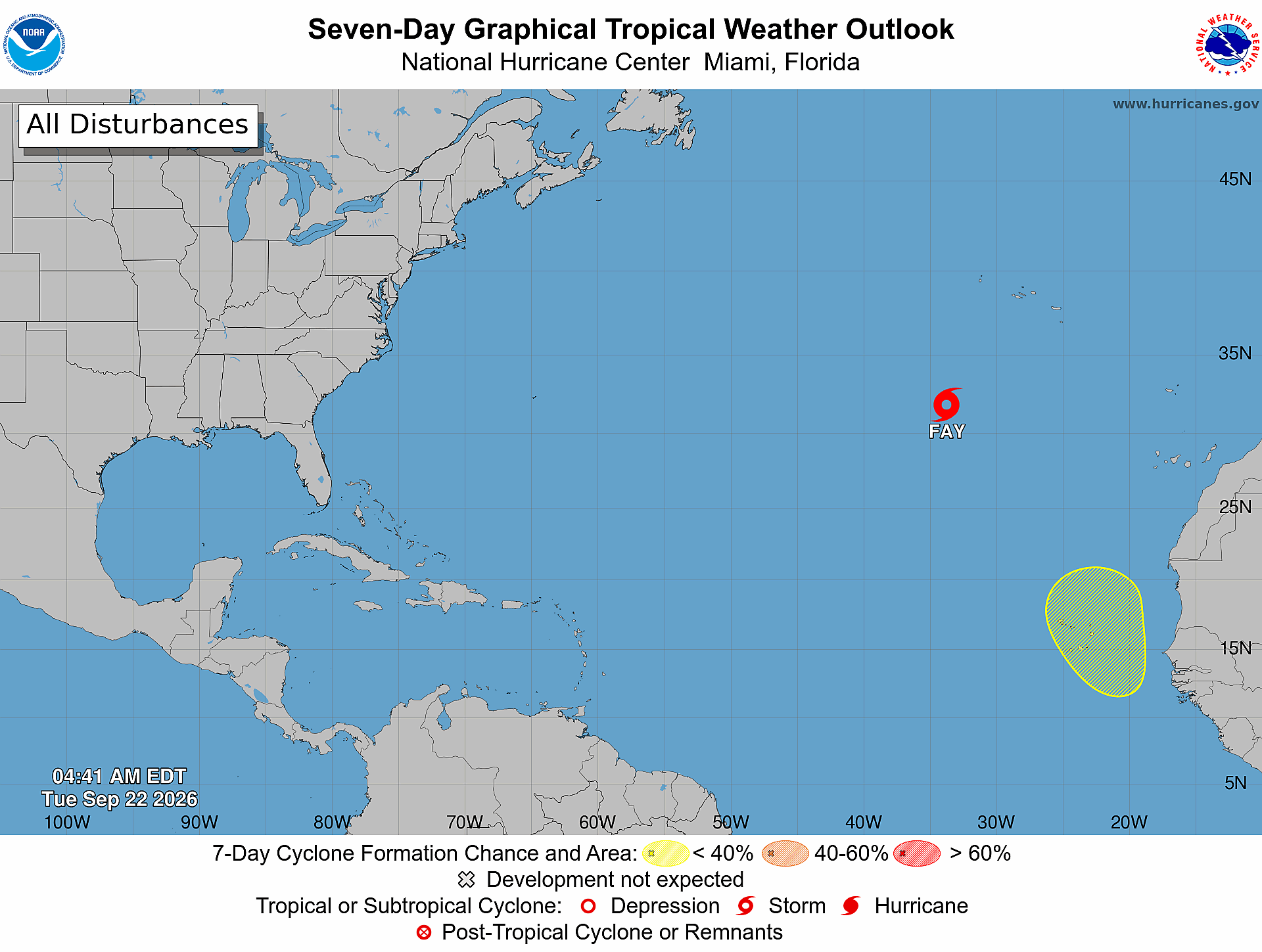
Quick Read
- Official outlook time: 2:00 AM EDT Tuesday, September 22, 2026. [1]
- Product: ABNT20 KNHC 220524 / TWOAT. [1]
- Area covered: The North Atlantic, Caribbean Sea, and Gulf of America. [1]
- Active system: Tropical Storm Fay, located several hundred miles southwest of the Azores. [1]
- Formation area: A tropical wave forecast to move off western Africa by Wednesday, with some slow development possible over the far eastern Atlantic. [1]
- 48-hour formation chance: Low — near 0 percent. [1]
- Seven-day formation chance: Low — 30 percent. [1]
- Cabo Verde note: NHC says interests in the Cabo Verde Islands should monitor the system because gusty winds and areas of heavy rain are possible there by the end of the week. [1]
What NOAA/NHC Is Reporting
NHC says environmental conditions are not expected to be particularly conducive, but some slow development of the tropical wave is possible as it moves west-northwestward or northwestward across the far eastern Atlantic. [1] The formation chances are exactly as NHC states them: low, near 0 percent through 48 hours, and low, 30 percent through seven days. [1]
The 5:00 AM EDT advisory places Tropical Storm Fay about 570 miles southwest of the Azores, with maximum sustained winds near 40 mph, no coastal watches or warnings, and no hazards affecting land listed. [3] NHC says Fay is likely to become a post-tropical remnant low later today. [3]
What This Means for the Treasure Coast
For Port Saint Lucie, Jensen Beach, Fort Pierce, and Vero Beach, these products do not identify a Treasure Coast track, landfall, watch, warning, or local impact. [2] [3] That is not a guarantee that conditions will stay the same. [1] The National Weather Service advises checking your evacuation zone through local government or emergency management and making an emergency plan. [4]
Practical Hurricane-Season Tech Check
Practical guidance from The IT Guys: Charge power banks, confirm emergency alerts are enabled, save critical contacts for offline access, and keep a separate backup of important documents and business data. [4] Test how you would communicate and keep essential devices running during a power or internet outage. [4] These are The IT Guys’ practical extensions of official prepare-ahead guidance—not a verbatim federal checklist—and they do not guarantee safety or business continuity. [4]
Official Sources and Preparedness Links
- NHC Atlantic Tropical Weather Outlook text product
- NHC Seven-Day Graphical Tropical Weather Outlook
- NHC Tropical Storm Fay public advisory
- National Weather Service hurricane planning guidance
- NOAA hurricane preparation resources
Reporting cutoff recorded by The IT Guys: 7:08 AM EDT (11:08 UTC) on September 22, 2026. [recorded by The IT Guys] This report distinguishes the 2:00 AM outlook from the 4:41 AM graphic and the 5:00 AM Fay advisory. [1] [2] [3] Conditions can change; use the newest official advisories for decisions. [3]