

Florida hurricane-season check for September 1, 2026: In its 2:00 AM EDT Atlantic outlook, the National Hurricane Center said it was issuing advisories on Tropical Storm Edouard over the northern Gulf of America. [1] For new development elsewhere in the basin, NHC stated: “Tropical cyclone formation is not expected during the next 7 days.” [1] Edouard is already an active tropical cyclone, so NHC does not assign it a 2-day or 7-day formation percentage in this outlook. Conditions and forecasts can change; use the current NHC advisories for storm-specific details. [3]
Quick Read
- Official text issue time: 2:00 AM EDT Tuesday, September 1, 2026. [1]
- Product: ABNT20 KNHC 010537 / TWOAT. [1]
- Area covered: The North Atlantic, Caribbean Sea, and Gulf of America. [1]
- Active system: Tropical Storm Edouard, located over the northern Gulf of America. [1]
- New formation outlook: “Tropical cyclone formation is not expected during the next 7 days.” [1]
- Formation percentages: NHC lists no separate disturbance or formation area, so the outlook reports no per-area 2-day or 7-day percentage. Do not convert that absence into an invented 0% value. [1]
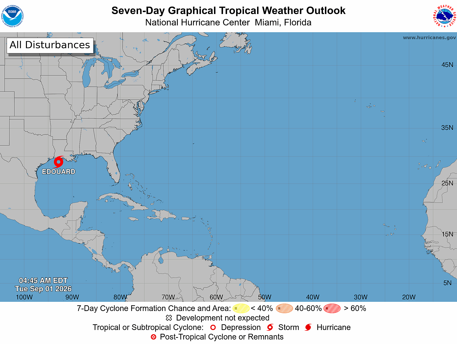
- Current graphic: The official seven-day map is valid at 4:45 AM EDT Tuesday, September 1, 2026; it labels Edouard as a storm in the northern Gulf and shows no shaded disturbance formation area. [2]
Active System: Tropical Storm Edouard
NHC’s outlook places Tropical Storm Edouard over the northern Gulf of America and directs readers to storm-specific public and forecast advisories. [1] Because Edouard is already an active tropical cyclone, the outlook does not give it a formation chance. Readers who need its latest position, forecast, watches, warnings, or hazard information should use NHC’s current cyclone advisory page rather than infer a track from the formation outlook map. [3]
No Separate Formation Areas Listed
Outside the active storm, NHC’s exact basin-wide statement is: “Tropical cyclone formation is not expected during the next 7 days.” [1] The product lists no separate disturbance or monitored formation area and therefore gives no per-area formation percentages. That is not the same as an all-clear for every weather hazard, and it does not replace advisories for Edouard.
What This Means for the Treasure Coast
For Port Saint Lucie, Jensen Beach, Fort Pierce, and Vero Beach, today’s outlook supports routine hurricane-season awareness—not an invented local track or impact claim. Keep preparations current, monitor official alerts, and follow local authorities if watches, warnings, or evacuation instructions are issued. [4]
Practical Hurricane-Season Tech Check
Practical guidance from The IT Guys: Charge power banks, protect important documents and photos with a separate backup, keep critical contacts available offline, enable emergency alerts, and test household or small-business continuity plans. These steps extend federal preparedness guidance but do not guarantee safety or continuity. [4] [5]
Official Sources and Preparedness Links
- NHC Atlantic Tropical Weather Outlook text product
- NHC Seven-Day Graphical Tropical Weather Outlook
- NHC current tropical cyclone advisories
- Ready.gov: Hurricanes
- NOAA: Hurricane preparation resources
Reporting cutoff: 7:14 AM EDT (11:14 UTC) on September 1, 2026. This report reflects the NOAA/NHC Atlantic Tropical Weather Outlook issued at 2:00 AM EDT [1] and the official seven-day graphic valid at 4:45 AM EDT [2]. Conditions can change; recheck the linked NHC products for the newest information.