

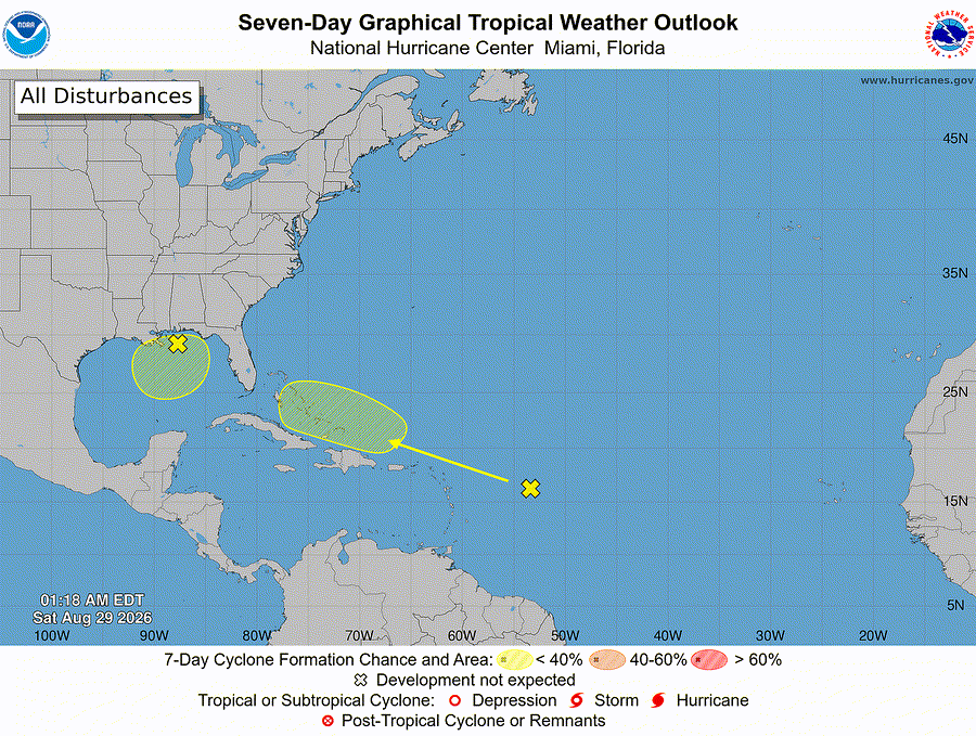
Florida hurricane-season check for August 29, 2026: The National Hurricane Center’s 2:00 AM EDT Atlantic outlook is monitoring two low-chance formation areas: the remnants of Dolly east of the Leeward Islands and a weak low in the northeastern and north-central Gulf of America. [1] NHC gives each area a formation chance of low, near 0 percent through 48 hours and low, 10 percent through seven days. [1] Those percentages describe the chance of tropical cyclone formation, not a track or Treasure Coast impact forecast, and conditions can change. [1]
Quick Read
- Official text issue time: 2:00 AM EDT Saturday, August 29, 2026. [1]
- Product: ABNT20 KNHC 290518 / TWOAT. [1]
- Area covered: The North Atlantic, Caribbean Sea, and Gulf of America. [1]
- East of the Leeward Islands (remnants of Dolly): low, near 0% through 48 hours; low, 10% through seven days. [1]
- Northeastern and north-central Gulf of America: low, near 0% through 48 hours; low, 10% through seven days. [1]
- Florida/Treasure Coast: This outlook does not establish a local storm track or local impact threat. Conditions and forecasts can change. [1]
Area 1: Remnants of Dolly East of the Leeward Islands
NHC says a tropical wave—the remnants of Tropical Storm Dolly—is several hundred miles east of the Leeward Islands. Redevelopment is unlikely while the wave moves westward to west-northwestward near 25 mph. NHC says the wave could bring locally heavy rains and gusty winds to portions of the Leeward Islands, the Virgin Islands, and Puerto Rico over the next several days. Formation chance: low, near 0 percent through 48 hours and low, 10 percent through seven days. [1]
Area 2: Northeastern and North-Central Gulf of America
NHC says disorganized cloudiness and showers over portions of the northeastern and north-central Gulf are associated with a weak area of low pressure. Development, if any, is expected to be slow while the system remains nearly stationary for the next several days. Formation chance: low, near 0 percent through 48 hours and low, 10 percent through seven days. [1]
What This Means for the Treasure Coast
For Port Saint Lucie, Jensen Beach, Fort Pierce, and Vero Beach, the practical takeaway is awareness—not alarm. The current outlook does not identify a Treasure Coast track, but late-summer tropical conditions can evolve. Keep routine hurricane-season preparations current and follow official alerts if watches, warnings, or evacuation instructions are issued. [1] [3]
Practical Hurricane-Season Tech Check
Practical guidance from The IT Guys: Charge power banks, protect important documents and photos with a separate backup, keep critical contacts available offline, enable emergency alerts, and test household or small-business continuity plans. These steps extend federal preparedness guidance but do not guarantee safety or continuity. [3] [4]
Official Sources and Preparedness Links
- NHC Atlantic Tropical Weather Outlook text product
- NHC Seven-Day Graphical Tropical Weather Outlook
- Ready.gov: Hurricanes
- NOAA: Hurricane preparation resources
Reporting cutoff: 7:04 AM EDT (11:04 UTC) on August 29, 2026. This report reflects the NOAA/NHC Atlantic Tropical Weather Outlook issued at 2:00 AM EDT [1] and the official seven-day graphic valid at 1:18 AM EDT [2]. Conditions can change; recheck the linked NHC products for the newest information.