

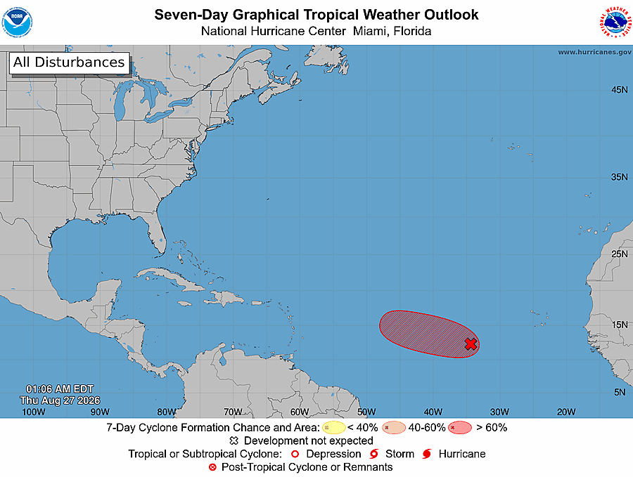
Florida hurricane-season check for August 27, 2026: At 2:00 AM EDT, the National Hurricane Center listed one Atlantic disturbance, Eastern Tropical Atlantic disturbance AL96. [1] NHC gives AL96 a high 70 percent chance of formation through 48 hours and a high 70 percent chance through seven days. [1] These are formation probabilities—not probabilities of reaching Florida—and conditions can change. [1]
Quick Read
- Official text issue time: 2:00 AM EDT Thursday, August 27, 2026. [1]
- Product: ABNT20 KNHC 270506 / TWOAT. [1]
- Area covered: The North Atlantic, Caribbean Sea, and Gulf of America. [1]
- Area being monitored: Eastern Tropical Atlantic (AL96). [1]
- Formation chance through 48 hours: high—70 percent. [1]
- Formation chance through 7 days: high—70 percent. [1]
- Florida/Treasure Coast: This outlook provides no forecast track toward Florida and does not establish a local landfall threat. [1]
What NHC Is Monitoring
Eastern Tropical Atlantic (AL96)
NHC says satellite imagery indicated that showers and thunderstorms associated with the low-pressure area several hundred miles west-southwest of the Cabo Verde Islands had become better organized overnight. [1] If that trend continues, NHC says advisories could be initiated on a short-lived tropical depression or storm later today. [1] Environmental conditions are expected to become hostile beginning Friday, likely ending the system’s chances for development. [1]
What This Means for the Treasure Coast
For Port Saint Lucie, Jensen Beach, Fort Pierce, and Vero Beach, this is a reason to stay aware and keep ordinary hurricane-season preparations current—not a reason to assume a local storm is coming. [1] [3] AL96 remains far across the eastern Atlantic near the Cabo Verde Islands, and this outlook gives it no forecast track toward Florida. [1]
Recheck the official products, and follow local emergency-management instructions if watches, warnings, or evacuation orders are issued. [3]
Practical Hurricane-Season Tech Check
Practical guidance from The IT Guys: Charge power banks, protect important documents and photos with a separate backup, keep critical contacts available offline, enable emergency alerts, and test household or small-business continuity plans. These steps extend federal preparedness guidance but do not guarantee safety or continuity. [3] [4]
Official Sources and Preparedness Links
- NHC Atlantic Tropical Weather Outlook text product
- NHC Seven-Day Graphical Tropical Weather Outlook
- Ready.gov: Hurricanes
- NOAA: Hurricane preparation resources
Reporting cutoff: 7:06 AM EDT (11:06 UTC) on August 27, 2026. This report reflects the NOAA/NHC Atlantic Tropical Weather Outlook issued at 2:00 AM EDT [1] and the official seven-day graphic valid at 1:06 AM EDT [2]. Conditions can change; recheck the linked NHC products for the newest information.