

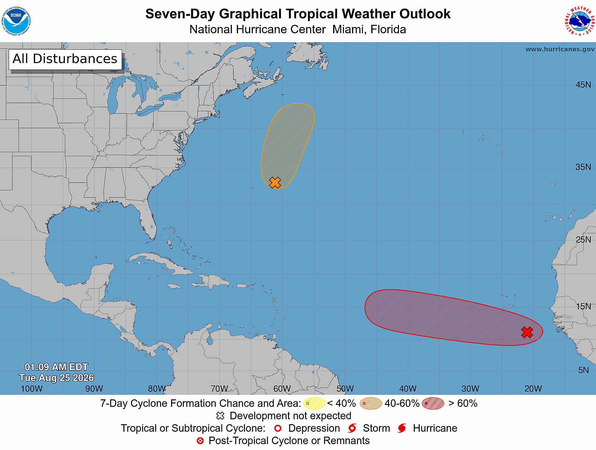
Daily Florida hurricane-season check for August 25, 2026: The National Hurricane Center is monitoring two Atlantic formation areas. One has a high 70 percent chance of formation during the next seven days; the other has a medium 40 percent chance. Formation chances describe development, not destination; this outlook does not establish a forecast track toward Florida, and conditions can change.
Quick Read
- Official text issue time: 2:00 AM EDT Tuesday, August 25, 2026.
- Product: ABNT20 KNHC 250507 / TWOAT.
- Area covered: The North Atlantic, Caribbean Sea, and Gulf of America.
- Areas being monitored: Central Subtropical Atlantic (AL95) and Eastern Tropical Atlantic (AL96).
- Central Subtropical Atlantic (AL95): Formation chance through 48 hours—medium, 40 percent. Formation chance through 7 days—medium, 40 percent.
- Eastern Tropical Atlantic (AL96): Formation chance through 48 hours—medium, 60 percent. Formation chance through 7 days—high, 70 percent.
- Active tropical cyclones: None listed in this Atlantic outlook. AL95 and AL96 are designated disturbances, not yet tropical cyclones.
- Florida/Treasure Coast: The outlook does not establish a Florida track or local landfall threat.
What NHC Is Monitoring
Central Subtropical Atlantic (AL95)
NHC says an area of low pressure a couple of hundred miles east-northeast of Bermuda is moving northward at 15 to 20 mph. The circulation remains broad and elongated, and shower activity is disorganized. It could still become a short-lived tropical depression or storm later today before increasingly hostile conditions tonight and Wednesday likely end its chances for development.
- Formation chance through 48 hours: medium—40 percent.
- Formation chance through 7 days: medium—40 percent.
Eastern Tropical Atlantic (AL96)
NHC says an area of low pressure a few hundred miles south-southeast of the Cabo Verde Islands is producing disorganized showers and thunderstorms. Conditions appear conducive for gradual development, and the system is likely to become a tropical depression during the next few days while moving westward to west-northwestward across the eastern and central tropical Atlantic. Conditions could become less conducive by the weekend.
- Formation chance through 48 hours: medium—60 percent.
- Formation chance through 7 days: high—70 percent.
Important: These percentages are formation probabilities, not probabilities of reaching Florida. NHC does not provide a Florida track or landfall forecast for either area in this outlook. A 70 percent formation chance does not mean a 70 percent chance of affecting the Treasure Coast.
What This Means for the Treasure Coast
For Port Saint Lucie, Jensen Beach, Fort Pierce, and Vero Beach, today’s outlook is a cue to stay aware and keep routine hurricane-season preparations current—not a reason to assume a local storm is coming. AL95 is east-northeast of Bermuda and moving northward. AL96 is far across the eastern Atlantic near the Cabo Verde Islands. This outlook gives neither disturbance a forecast track toward Florida.
Tropical systems and probabilities can change between NHC issuances. Recheck the linked official products, and follow local emergency-management instructions if watches, warnings, or evacuation orders are issued.
Practical Hurricane-Season Tech Check
- Charge power banks and test the cables used by every household phone.
- Confirm important documents and irreplaceable photos have a backup that is not stored only on one computer.
- Save account-recovery details and critical contacts somewhere available during an internet outage.
- Enable emergency alerts on each phone and test a battery-powered weather radio.
- Review family, pet, medication, and evacuation plans before a storm threatens.
- Small businesses should test cloud backups, UPS batteries, remote-access procedures, and a simple staff communication plan.
Official Sources and Preparedness Links
- NHC Atlantic Tropical Weather Outlook text product
- NHC Seven-Day Graphical Tropical Weather Outlook
- NHC hurricane preparedness guidance
- Florida Division of Emergency Management: Plan and Prepare
Reporting cutoff: 7:02 AM EDT (11:02 UTC) on August 25, 2026. This report reflects the NOAA/NHC Atlantic Tropical Weather Outlook issued at 2:00 AM EDT and the official seven-day graphic valid at 1:09 AM EDT. Conditions can change; recheck the linked NHC products for the newest information.