

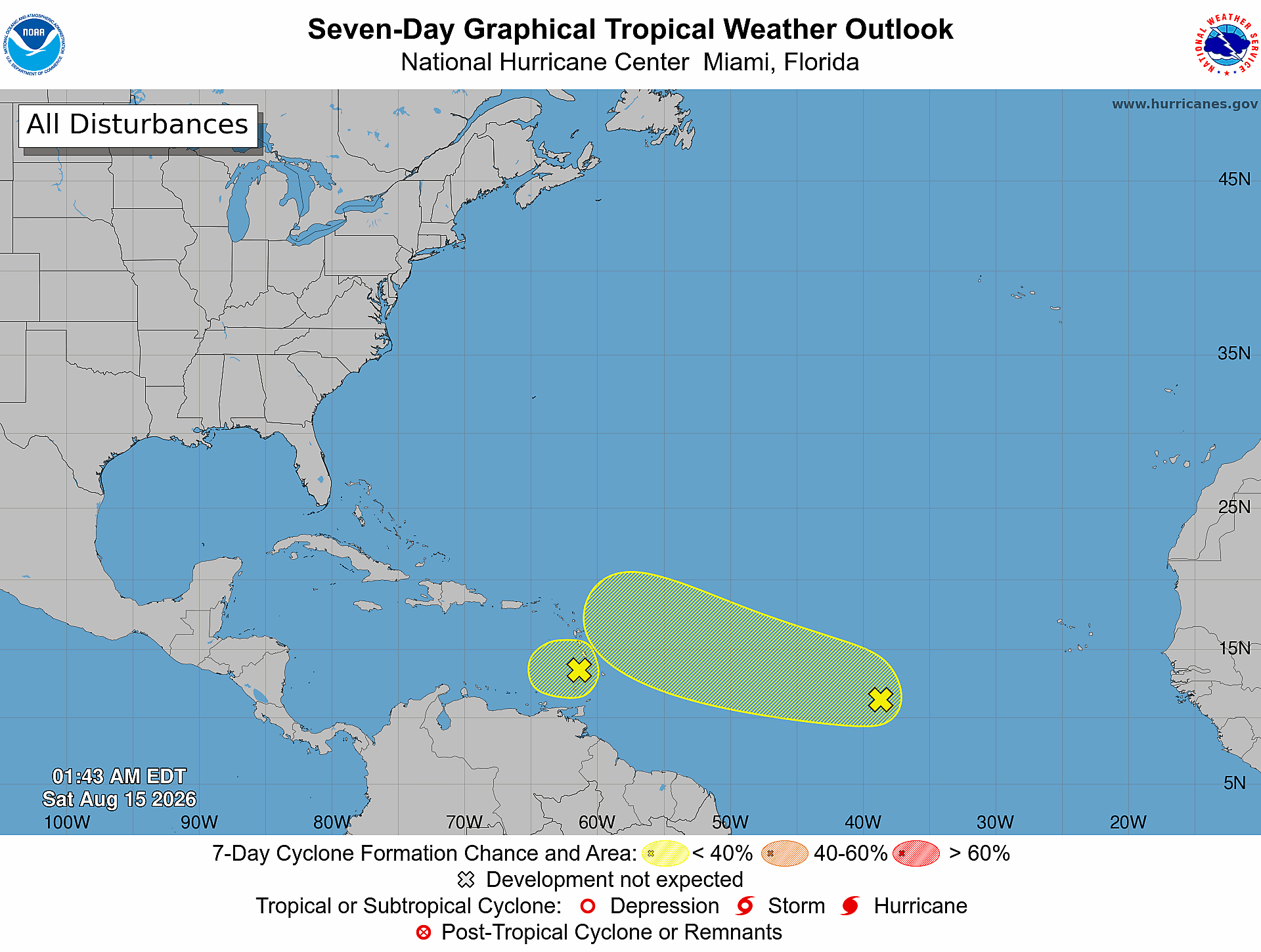
Daily Florida hurricane-season check for August 15, 2026: The National Hurricane Center is monitoring two tropical waves: one near the Windward Islands and another in the central tropical Atlantic. Their seven-day formation chances are 10 percent and 20 percent, respectively. This outlook does not identify a current Florida threat, landfall forecast, or forecast track. Conditions and formation chances can change, so Treasure Coast residents and businesses should keep checking official updates.
Quick Read
- Official issue time: 2:00 AM EDT Saturday, August 15, 2026.
- Product: ABNT20 KNHC 150543 / TWOAT.
- Area covered: The North Atlantic, Caribbean Sea, and Gulf of America.
- Near the Windward Islands (AL92): Formation chance through 48 hours: low—10 percent. Formation chance through 7 days: low—10 percent.
- Central Tropical Atlantic (AL94): Formation chance through 48 hours: low—20 percent. Formation chance through 7 days: medium—20 percent, exactly as stated in the current NHC text product.
- Florida/Treasure Coast: This outlook does not provide a Florida track or landfall forecast. Formation chance describes whether a disturbance may develop, not where it will go.
What the National Hurricane Center Is Monitoring
Near the Windward Islands (AL92)
NHC says a tropical wave near the Windward Islands is producing gusty winds and an area of showers and thunderstorms. The system is moving into increasing upper-level winds and drier air, and its potential for tropical cyclone formation has decreased. Development is highly unlikely, but strong gusty winds to near gale force and areas of heavy rain are possible across portions of the Lesser Antilles today.
- Through 48 hours: low—10 percent.
- Through 7 days: low—10 percent.
Central Tropical Atlantic (AL94)
NHC says a tropical wave more than 1,000 miles west of the Cabo Verde Islands continues to produce disorganized showers and thunderstorms. Some slow development could occur during the next couple of days. After that, the system is expected to encounter strong upper-level winds, decreasing its chances for development.
- Through 48 hours: low—20 percent.
- Through 7 days: medium—20 percent, as printed by NHC.
What This Means for the Treasure Coast
For Port Saint Lucie, Jensen Beach, Fort Pierce, and Vero Beach, today’s Atlantic outlook is a reason to stay informed—not a signal to assume a Florida impact. Neither monitored area has a forecast track or Florida landfall forecast in this product. Tropical outlooks are updated routinely and can also change between scheduled issuances.
Check the latest official NHC products before making weather decisions, and rely on local emergency-management instructions if watches or warnings are ever issued for our area.
Practical Hurricane-Season Tech Check
- Charge power banks and test the cables needed for every household phone.
- Confirm important documents and irreplaceable photos have a backup that is not stored only on one computer.
- Save key contacts and account-recovery information somewhere you can access during an internet outage.
- Enable emergency alerts on each phone and keep a battery-powered weather radio available.
- Review your family, pet, medication, and evacuation plans before a system becomes an immediate concern.
Official Sources and Preparedness Links
- NHC Atlantic Tropical Weather Outlook text product
- NHC Seven-Day Graphical Tropical Weather Outlook
- Ready.gov hurricane preparedness
- Florida Division of Emergency Management: Plan and Prepare
Source note: This report reflects the NOAA/NHC Atlantic Tropical Weather Outlook issued at 2:00 AM EDT on August 15, 2026, and the official seven-day graphic timestamped 01:43 AM EDT. Forecasts and formation chances can change. Recheck the linked NHC products for the newest information.